












 Pin
Photo Courtesy of Visit The USA
Synopsis: In northeast Wyoming, a grey column of rock stands about 865 feet above its base, looking like the stump of a tree nobody has had the nerve to fell. Geologists agree it began as molten rock that cooled underground roughly 50 million years ago, then waited while erosion cleared away its blankets. They do not agree on much else. This guide covers the rock, the strange columns, the name, the legends, the climbers, the parachutist and the questions still unanswered.
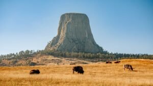
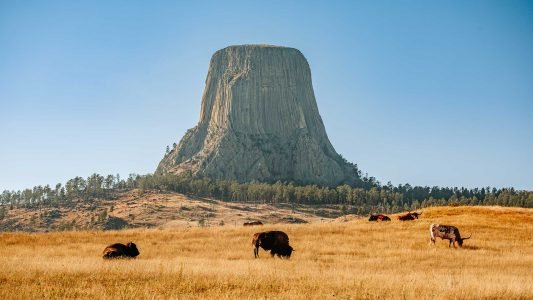
Northeast Wyoming is mostly rolling grass, pine hills and a sky with nothing to do but be enormous. Then the land seems to lose its temper, and Devils Tower goes up like a grey stump left behind by a lumberjack the size of a county.
It stands about 865 feet above its base and roughly 1,270 feet above the Belle Fourche River, with a flat top at 5,117 feet above sea level. Its sides are grooved into long columns, as though the rock had been given a very thorough lesson in pleating.
People have stared at it for thousands of years, and scientists have argued about it for well over a century. The rest of this guide takes the arguments one at a time. First, the quick facts:
- Location: Crook County, northeast Wyoming, USA
- Height: About 865 feet above its base
- Rock: Phonolite porphyry, a cooled igneous rock
- Age: Around 50 million years
- Status: America’s first national monument, proclaimed September 24, 1906
Table of Contents
What Is the Rock Made Of? Phonolite Porphyry Explained
 Pin
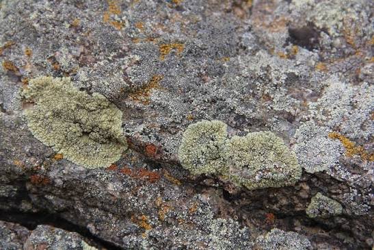
Phonolite porphyry: grey when fresh, brownish and lichen-spotted when weathered / Photo Courtesy of NPS Archive
The Tower is not granite, although it has the same grumpy look. Geologists call it phonolite porphyry, which sounds like an expensive cheese but is a crystalline igneous rock, born from molten material that cooled and set hard.
“Phonolite” describes a fine-grained rock made mostly of feldspar. “Porphyry” means big crystals scattered through a finer background, like raisins in a very old pudding. Fresh rock is grey. Weather turns the surface light grey or brownish, and lichens add patches of green, yellow-green or brown.
The hardness matters. The rocks around the base are soft sandstone, shale and gypsum, and they lost their argument with wind and water ages ago. The phonolite did not.
- Type: Igneous (formed from cooled magma)
- Main mineral: Feldspar
- Colour: Grey when fresh, grey-brown when weathered, often dotted with lichen
- Neighbours: Red, yellow and grey sedimentary layers
How Was It Formed? The Magma Story, Step by Step
 Pin
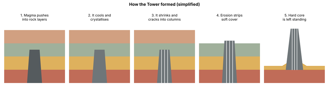
Five-step diagram showing magma pushing into rock layers, cooling, cracking into columns, being uncovered by erosion and finally standing alone / Photo Courtesy of Horizon Dwellers
The most common telling starts about 50 million years ago, when the Rocky Mountains and the Black Hills were being heaved upward. Hot magma pushed into the layers of rock beneath what is now Wyoming. It sat one to two miles below the surface, which was, for a mountain-to-be, a fairly dull address.
Cooling rock is slow, patient and thorough. Over a very long stretch of time the magma crystallised into phonolite porphyry, shrinking a little as it did so. That small shrinking turns out to be the whole secret of the columns, which the next section explains.
Then erosion went to work on the soft rock above. Somewhere between 5 and 10 million years ago it began to uncover the hard core, and a thing born underground ended up the tallest feature for miles.
- Magma pushes into the rock layers underground.
- It cools slowly and crystallises.
- It shrinks and cracks into columns.
- Erosion strips away the softer cover.
- The hard core is left standing.
Why Does It Have Those Giant Columns? Columnar Jointing Explained
 Pin
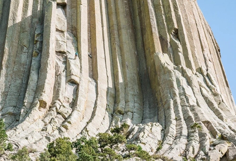
Devils Tower Close-up of the vertical columns with a climber or visitor for scale, or the boulder field at the base / Photo Courtesy of Adrift Aesthetic
As the rock cooled it shrank, and shrinking rock has to crack somewhere. The cracks spread from points of tension and met at tidy angles, slicing the mass into long vertical columns. Geologists call this columnar jointing, which is a polite way of saying the rock fell out with itself in a very orderly manner.
The columns are not all hexagons, whatever the postcards suggest. The old USGS survey notes they can have four, five, six or more sides. Near the top they taper and sometimes merge, and at the bottom they flare out into a broad, heavy base.
Columns like these turn up elsewhere, including a well-known site in California, but the size and the rock type here make the Tower something of a one-off, according to the National Park Service. Pieces keep breaking away and gathering at the foot in a vast heap of boulders.
- Cause: Shrinking as the rock cooled
- Shape: Mostly four to six sides, sometimes more
- Result: A huge boulder field around the base
How Erosion Uncovered the Stone: Layers, Rivers and Time
The ground around the base is a layer cake of red, yellow, grey and green sedimentary rock, about 400 feet thick in total. The oldest visible part, the red Spearfish Formation, was laid down in the Triassic period, when a shallow inland sea covered much of the central and western United States.
Above it sits the gypsum-rich Gypsum Spring Formation, left behind as mineral-heavy water dried up, and then the Sundance Formation of the Late Jurassic. These rocks hold the fossil remains of sea creatures such as oysters, belemnites and crinoids, so the bottom of the Wyoming prairie was once, quite literally, the bottom of the sea.
Rain, frost and the Belle Fourche River carried the soft rock away and left the hard core behind. The job is not finished. Geologists say the Tower was once taller, and in some unimaginably distant future it will wear away completely.
- Spearfish Formation: Triassic, red siltstone and sandstone
- Gypsum Spring Formation: Middle Jurassic, gypsum and red shale
- Sundance Formation: Late Jurassic, shale and sandstone
Volcano, Laccolith or Stock? The Geology Mystery Nobody Has Settled
 Pin
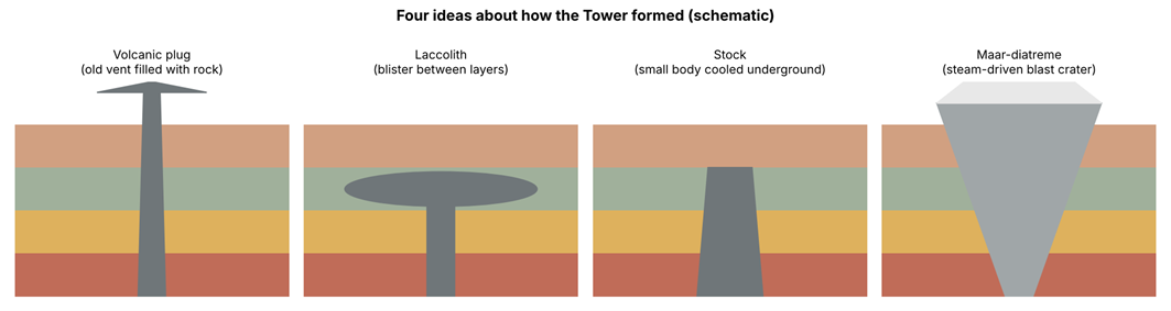
Four schematic diagrams comparing a volcanic plug, a laccolith, a stock and a maar-diatreme / Photo Courtesy of Horizon Dwellers
Here is the awkward part. Geologists agree the rock was molten and rose from below. The National Park Service says they still cannot agree on how the magma cooled or how it fits the geology around it, and the argument has been running since the 1800s.
In 1888 Carpenter read it as a volcanic plug. In 1901 Jaggar preferred a laccolith, a blister of magma pushed between layers of rock. The simplest modern idea is a stock, a small body of magma that cooled underground. Another proposal calls it the remains of a maar-diatreme volcano, where rising magma met groundwater and caused a steam-driven blast.
Evidence is the trouble. Erosion has taken the roof, and with it the proof. About three miles northwest sit the Missouri Buttes, smaller columned rocks of similar age, which make the puzzle more interesting and no easier.
- Volcanic plug
- Laccolith remnant
- Stock (underground intrusion)
- Maar-diatreme volcano
Bear Lodge: What the Tower Means to Native Nations
Long before any surveyor arrived with a notebook, the Tower already had names. The Lakota call it Mato Tipila, or Bear Lodge. The Cheyenne and Arapaho say Bear’s Tipi or Bear’s House, and the Kiowa say Aloft on a Rock or Tree Rock.
More than 20 tribes regard it as sacred. Ceremonies, vision quests and prayers have taken place here for generations, and visitors sometimes see cloth offerings tied near the trail. These are someone’s worship, and they are best left exactly where they are.
The best-known story, told in different forms by the Kiowa, Lakota and Cheyenne, has young girls chased by a giant bear. They climbed onto a low rock and prayed, and the rock rose into the sky while the bear’s claws scored deep grooves in its sides. In the Kiowa version the girls became the seven stars of the Pleiades.
Where Did the Name Come From? A Mistranslation That Stuck
In 1875 Colonel Richard Irving Dodge led an army expedition through the Black Hills, and his interpreter reportedly turned a Native name into “Bad God’s Tower.” Dodge called the rock one of the most remarkable peaks in any country and put the name into a book.
The book was popular, and the name took root, even though maps and government papers went on saying Bear Lodge for years. One theory points to two similar-sounding Lakota words, one meaning bear and the other something sacred, which a hurried ear could easily mix up.
When the rock became a national monument in 1906, the English name was made official and the apostrophe went missing, blamed on a clerical error in one account and on standard mapping practice in another. Many Native groups still find the name disrespectful, and calls to restore Bear Lodge have not faded.
- 1875: Dodge expedition records the English name
- 1906: Name becomes official
- Today: The debate over Bear Lodge continues
America's First National Monument and a Famous Film Role
On September 24, 1906, President Theodore Roosevelt used the brand-new Antiquities Act, a law meant to protect historic landmarks and objects of scientific interest, to make the Tower the first national monument in the United States. The Grand Canyon, often assumed to be first, had to wait.
The protected area covers only about two square miles, which is not much land for such a lot of rock. For decades it was a quiet stop for travellers who had heard there was something odd standing in Wyoming.
Then, in 1977, Steven Spielberg’s film Close Encounters of the Third Kind chose the Tower as the place where visitors from space would meet humanity. Attendance almost doubled, and the rock became the most photographed lump of phonolite on Earth.
- Proclaimed: September 24, 1906
- Law used: Antiquities Act
- Area: About two square miles
- Film: Close Encounters of the Third Kind, 1977
Climbing History: The Ladder, the Parachutist and the Modern Routes
The first known ascent took place on July 4, 1893. Local ranchers William Rogers and Willard Ripley hammered wooden pegs into a crack on the southeast side and built a ladder of about 350 feet. Parts of it can still be seen from the trails, a monument to cowboy stubbornness.
Technical climbers reached the summit without the ladder in 1937. In October 1941 the parachutist George Hopkins dropped onto the flat top, roughly the size of a football field, and promptly lost the rope he meant to descend by. He spent six days up there in cold, rain and sleet before climbers rescued him. Accounts differ on whether it began as a bet or a publicity stunt.
Today climbers use more than 200 reported routes. Under a 1995 management plan they are asked to stay off in June, out of respect for tribal ceremonies, and that voluntary closure has cut June climbing by about 85 percent. Seasonal closures also protect nesting raptors.
Visiting Respectfully: Trails, Closures and Travel Tips
The visitor center sits near the base, and a loop trail of a little over a mile circles the Tower, with longer paths through pine woods and prairie. Walking it shows the columns, the boulder field and the old wooden ladder, all at a comfortable distance from the weather.
Bring water and an extra layer, because Wyoming weather changes its mind quickly, as Hopkins found out. Check the National Park Service website before you go for current hours, fees and trail conditions, since these change.
Treat prayer cloths and offerings as worship, not decoration. If you plan to climb, plan around June. And for photographs, early morning and late afternoon usually give the columns their deepest shadows.
- Stay on marked trails
- Leave offerings untouched
- Check current rules with the park before travelling
- Avoid climbing in June
FAQs
About 865 feet above its base and roughly 1,270 feet above the Belle Fourche River. The flat summit sits at 5,117 feet above sea level.
Around 50 million years, though most of that time it was hidden underground. Erosion began exposing it 5 to 10 million years ago.
Nobody can say for sure. Geologists agree it was magma, but still debate whether it was a plug, laccolith, stock or maar-diatreme. The Park Service calls the question unsettled.
An 1875 expedition’s interpreter reportedly mistranslated a Native name as “Bad God’s Tower.” Many tribes call it Bear Lodge, and the apostrophe vanished when the name became official.
Yes, but climbers are asked to stay off in June out of respect for tribal ceremonies. Seasonal closures also protect nesting raptors, so check current rules with the park first.








 Login with Google